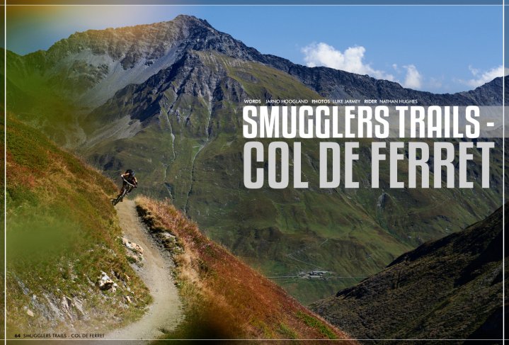
Smuggler Trails - Col de Ferret
Issue 64 / Wed 7th Apr, 2021
Centuries ago outlaws accidentally created some of the worlds best border crossing singletrack. In this issue we check out the Col de Ferret, connecting Switzerland and Italy under the watchful eye of Europe’s highest mountain, Mont Blanc.
Over the centuries, there have always been many different trading routes crossing the mountain passes, bringing in luxury goods over from far away valleys and exotic regions. Modern-day transport is of course done by rail and trucks, but back in the good ol’ days, it was up to horse-drawn carriages and donkeys to get the goods from A to B.
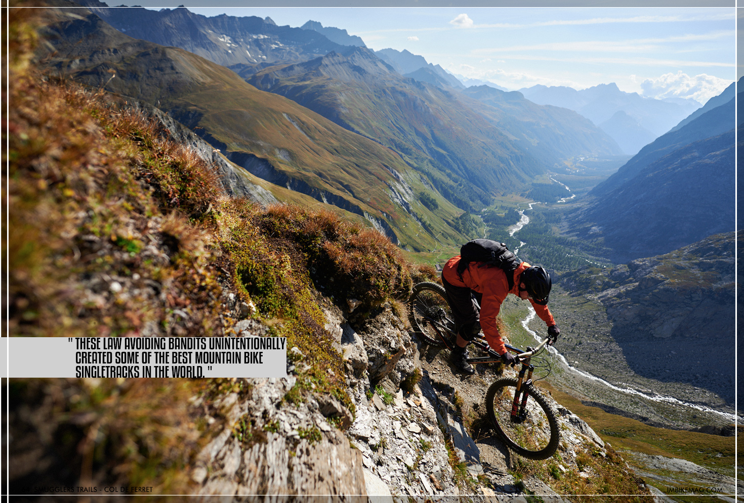
Most of the popular trading routes are now hassle-free with tunnels connecting the valleys, but in the past, it took a lot more effort to transport stuff over high mountain passes. Of course, these routes were heavily patrolled and taxed by the local aristocrats. And when there are taxes, there are people trying to avoid them. Taking the lesser travelled routes across mountain passes, these law avoiding bandits unintentionally created some of the best mountain bike singletracks in the world.

In this new series, we will travel across the European Alps, following in the footsteps of the smugglers of the past to rediscover the ancient routes in between countries.
First up is the Col de Ferret, which is situated just south of the Mont Blanc massif just north of the Col du Saint Bernard. On the Swiss side, the Val Ferret runs from the col, down past the hamlet of La Fouly towards Orsieres and the Rhone valley. The Italian side of the Val Ferret takes you to Courmayeur and further down the Aosta Valley towards the Po basin.
The main transit route in this region for centuries has always been the col du Grand Saint Bernard. Used since the Roman times, famous for its hospice, the rescue dogs and of course Napoleon crossing the pass with 40.000 men. These days there is a tunnel linking the two countries, and the high mountain pass is only used by the people that like to take the long but scenic route. Although only 17 meters higher than Saint Bernard, the steep Italian side of the Col de Ferret made it a much less suitable route to cross for travellers and merchants. For the outlaws moving their contraband, however, this was no problem. Once in the Italian side of the valley, it was an easy road leading to the settlement of Courmayeur.
These days, the col is frequently used by hikers that do the Tour de Mont Blanc, the popular 170km hiking trail that circles the highest mountain in Europe. Besides the passing hikers, the Val Ferret is a sparsely populated valley with less than 800 inhabitants. The last hamlet of significance is La Fouly. A cute alpine village, with a campsite and some restaurants, is where we start off our ride.
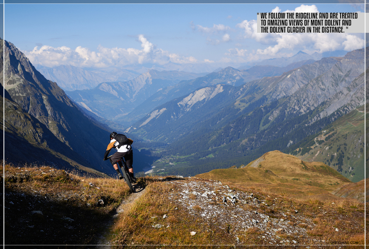
Our two-wheeled adventure takes us out of La Fouly and past the collection of houses known as Ars Dessous. We cross the stream and head up on the gravel road. Right when we top out of the tree line, we come across a classic high alpine farm. In case you’re already hungry this is the place to stop for a coffee and some homemade cake. We’ve had a big breakfast and a packed lunch in the bag, so we continue on as the gravel road switches to singletracks. We’re not sure if it’s the views that are breathtaking or the altitude but as we close to the Grand Col de Ferret (2536m) the legs start to burn. With most of the climbing done, we take a moment to eat our sandwiches and take in the surroundings. The Grand Col de Ferret is a crossroads with the option to descend into Italy, towards mountain refuge Elena, or to continue north on the ridgeline. We follow the ridgeline and are treated to amazing views of Mont Dolent and the Dolent glacier in the distance.

As we cross the Italian border, there is no sign of Carabinieri or Border patrol. The traverse takes us around de Tete de Ferret (2713m) and down some heavenly singletrack towards the Petit Col de Ferret. The glaciers are radiating in the sunlight as we arrive at the second crossroads, the Petit Col de Ferret. I’m pretty sure being a smuggler back in the day was not the easiest and most glorious way to make a living, I’d be happy to sign up just for the views.
As we take a look at the trail that's snaking down into Italy on our left, we know we definitely need to return here again for a multi-day mission. The questions then would be, take more gear and camp, hope for good weather and sleep under the stars or go all out luxurious and spend the night in a mountain hut. Climbing and descending while carrying tents, sleeping bags and a three-course meal has never been my favourite, but with all the new bike packing kit on the market, I might give it another go.
We take a few more pictures, but as the sun slowly moves behind the mountain peaks, it’s time for us to get out the knee pads and get ready for the 1000m descent back to La Fouly.
We agree there is no time to waste, as none of us brought lights, and we have no idea how smooth the trail is. As the Alpine trails are not built with mountain bikers in mind, it might very well be unrideable rock sections followed by death steep exposure bits.
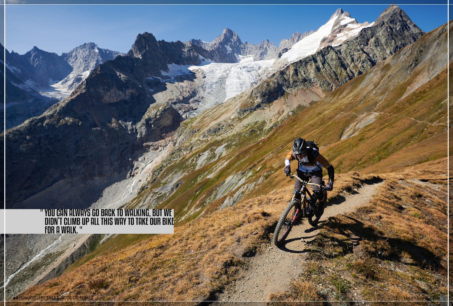
Of course, you can always go back to walking, but we didn’t climb up all this way to take our bike for a walk. The first few meters were already looking good. No real exposure on this part of the trail and smooth dreamy singletrack with the occasional rock section to keep us entertained. It’s hard to stay focussed on the trail with views like this! We resist the urge to stop to take more pictures as we can see our destination already in the shadow of mighty Mont Dolent.
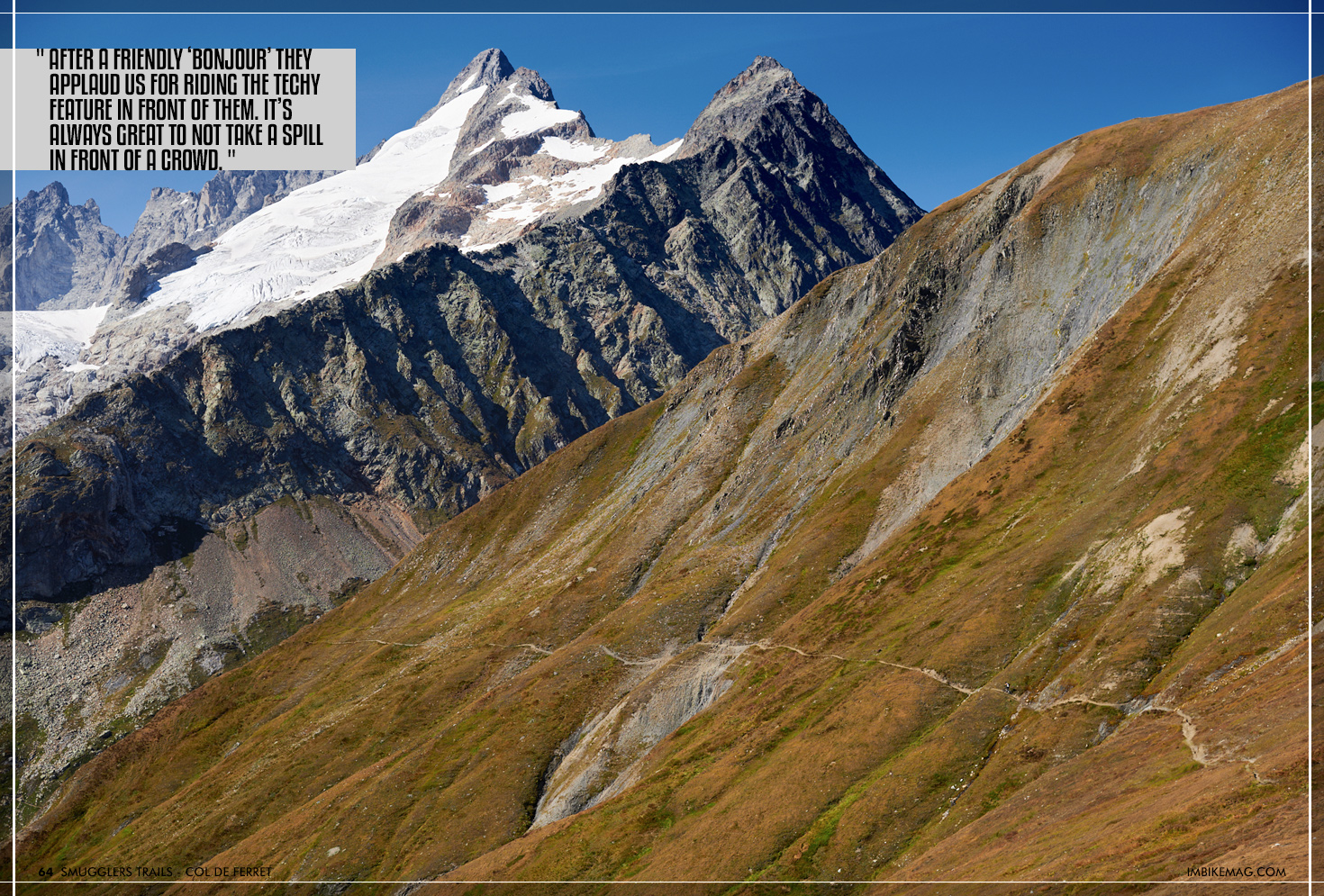
Razzin’ down the trail we overtake a group of hikers, they will most definitely arrive in the dark. After a friendly ‘bonjour’ they applaud us for riding the techy feature in front of them. It’s always great to not take a spill in front of a crowd.
The trail is nothing but pure bliss. The many hikers on the TMB make the trail smooth, but definitely off-limits in the summer months. Although hike trails are shared, you don’t want to stop every 100m to let a group of hikers pass. Autumn is prime time for this ride, although you do want to start early to avoid descending in the dark. We were lucky enough to not have any mechanicals, but we were definitely just one flat tire away from descending by the light of our iPhones.
Riding back into the village, the sun has definitely disappeared behind the horizon. Temperatures suddenly dropped and the down jacket comes out of the bag to warm us up. Sadly none of the restaurants and bars are open (thanks Covid). It would’ve been great to warm up with some local mountain food.
It’s not too hard to imagine how this place would’ve looked a few hundred years ago. Not much has changed. A few more houses and the road now covered in tarmac, but all in all, it looks like time stood still here. As we watch the nightfall we try to imagine what it would be like to venture out the same route on a horse or donkey packed with contraband. Hoping you will be able to evade the border patrol, and praying the storms will stay away.
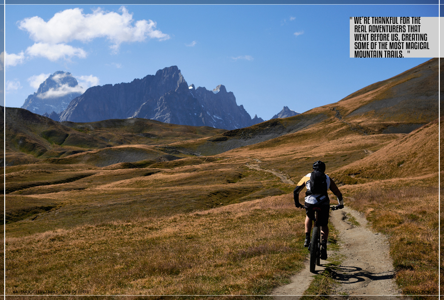
It’s hard to imagine life without weather apps, navigation apps and Goretex clothing. In the end, however, we’re thankful for the real adventurers that went before us, creating some of the most magical mountain trails. We can’t help but wonder about the other trail treasures that await us along the borders.
By Jarno Hoogland
Jarno's life has revolved around two wheels ever since he swung a leg over his first BMX at age 4. After a BMX and DH racing career, he moved on to work for bike shops, distributors and brands before ending up in the editors seat at IMB. Based in the ultimate testing ground in the Swiss mountains, he runs his guiding operation and makes sure every IMB issue is filled with top notch content.